Welcome In...

Welcome In...
Coach Howard And I are Happy You're Here...

Wednesday, August 24, 2011

You Don't Have To Go Home...

....but you should probably get the heck out of the Bahamas.

Seriously.

120 mph winds, and some folks are deciding to keep the party rockin'! Who am I to judge though, I'd do the same thing.

Heck... I'd ride a wild eyed stallion while wielding a trident right into the heart of this beast.

But I have neither of those things, so I'm in a Daytona Beach McDonalds writing this.

I just left the International Airport over the by the Daytona 500 Speedway. That's where the final flight off of Abaco landed Wednesday.


That's Scott Duchesne, AirGate Aviation Pilot. He made 2 runs to the Bahamas Wednesday getting tourists of the islands.


The last one... can you imagine? You're one of the last 6 passengers off the island before the most furious of nature's creations pressure washes the northern Bahamas.


AirGate Aviation runs shuttles back and forth from the Bahamas out of Daytona and even St. Augustine.

They had the last plane off Abaco... and it was 9 deep. 6 humans and three dogs. I found it amusing how each group had their own dog. PHOTO TIME:


There's a shot of the plane.
Not a bad lifestyle... hopping over to the Bahamas... but there's always the stray hurricane you'll have to deal with too.

I'm not advertising for AirGate, they did not pay me... I promise. If they had I would be writing this from a classier joint.

But, just a vacation travel tip... maybe think about them next time you want to jump to the Bahamas... Daytona and St. Augustine both have their own U.S. Customs departments, so you don't have to go to some huge mega airport. I watched the customs process today, and when you're flying with 5 other people, that whole thing moves really quick.

I'm not sure about prices but click anywhere on this sentence to go to their website, I'm sure they'll fill you in on all that. Even if it's a little more expensive, it might be worth it to avoid the hastle.

Anyway, I'm not sure how I went from meteorologist to reporter to travel agent so fast... but it's time for me to get outta here.

Let's watch this beast take the turn now...


It's like watching a 300,000 ton mega tanker try to change course, you know it can do it... but man does it make you nervous.


Talk to you soon.
Mahalo,
Lew  


Tuesday, August 23, 2011

I've got very expensive sand in my shoes...

Before I venture out of the office tonight on my way home to cook my wife a fine dinner, ((It's taco night at the Turner house)), I want to reflect, take a deep exhale, and pause to look back over the last couple days.


wake up jerk! You gotta make your wife tacos....


Nah, I wasn't really sleeping, it was all an illusion... I'm busy thinking, thinking about cones and stuff. I've gotten to the point where I'd like to punch the cone right in its "uncertainties."

Irene has made a pronounced shift... the track seems to take it through the Outer Banks and then on to New England where this will be a big problem.

But first, this thing is just going to wreck the Bahamas.

I'm not going to post a cone tonight...  though it's easy to find... just click here.

As far as what we're going to get in Jacksonville... winds gusting to 40 or 50 at the beach Friday. 25 foot seas off shore... and 10-15 foot surf. Huge surfing weekend, in fact you can will $1000 if you get a pic of yourself on the largest wave. Salt Life is putting on a big wave contest, click here to learn about that.

Things will rapidly improve and get pretty decent for the weekend.

Speaking of the large waves, that'll mean large erosion as well. Not don't everyone get all excited at once! I know the talk of erosion gets most people so worked up they can't contain their emotions, but hang with me for a second.

So Army Corps of Engineers just finished an $11 million beach renourishment. Pumped a bunch of sand onto 6.7 miles of beach. And now Irene is gonna come and suck some of it up in the backwash of some large waves.

And the Army Corps are cool with it. That's what it's there for... to protect the beach and especially the dunes... that way those aren't washed out to sea.

As for my loafers full of sand... I'll just put that in a bag and see if the ACOE will cut me a check.

Turnerloose on a new hair piece...

I'll need one after the last couple of days... I've just about pulled out every hair in my old one.

Just stressed, sorry about the imagery.

Here's a look at the latest cone... you've probably seen enough cones, huh?


Jacksonville out of the cone... keeps shifting east...
 This is just a quick post with the latest info... no need to get too in detail... Carolinas still need to watch this and be concerned, the First Coast and SE Georgia will just have some good surf and a stiff breeze by the end of the week.

But, look at it this way, now you've got a 'fridge full of milk and bread... time for a pb&j party.

In case you missed it yesterday, here's a look at what some Brunswick shrimpers are doing ahead of this storm.

Major storm, Carolinas... if it hits the U.S. at all (yep, a complete miss is totally possible too).

Mahalo,
Lew

Morning Discussion... I'm sorry about the math!

So, we've got a Cat 2 hurricane 950 miles from Jacksonville, about to plow through the Bahamas and make some kind of turn in the process.

((sips coffee, looks at NHC forecast, spits coffee onto computer monitor))


That's what made me sppiittt meey coffee everywhere... sorry, my keys are sticking... one sec.

That's better.

So this image is much different than the image 24 hours ago that had Jacksonville in the center of the track... and then 18 hours ago that had Charleston in the center of the track.

And if you remember, my original forecast was for somewhere around Charleston (my exact words were between Savannah and Charleston, Edisto).

So you're probably wondering if I'm going to adjust my forecast.

No, I'm sticking by my original call... however, with history punching me in the gut right now, I must admit that a coastal NC hit looks very likely right now as well. I mean, how many times have we watched these re-curves do this? Example:

Earl
Floyd
Bertha
Dennis (1999, strange track, but had recurve)
I'm done listing now... point is, it happens.

But think about it like this, the track all depends on computer models! The cone you see up there is derived from a consensus of computer models. I mean, I understand that computer models are great, but are we forgetting what happened a couple weeks ago with Emily? that thing was going to emerge and hit the US too... but it died.

Granted... it was much weaker, had a much different track, and had to deal with Hispanola... yikes. But we've got a lot to consider as this storm makes its way through the Bahamas. I still think both Carolinas and Georgia must be major hurricane ready, as in ready to walk out the door with a bag, dog and guitar.

For us here in Northeast Florida, let's be ready for the potential for some big winds on Friday, perhaps some bridge closures (thanks Mike Prangley) and power outages. But we won't be running for the hills here.

Southeast Georgia: have a shave kit and couple pants and shirts packed just in case this forecast shifts.

We'll talk again later... we need to watch trough moving into eastern US... and subtropical ridge... those will determine forward speed and steering of this thing. And yes, those too can shift... which would change the computer model input...

Algebra time...

2x(3y+z) =
Assume:
x = 1
y = 1
z = 1

you get 8.

Now let's just change the numbers slightly... each variable equals 2...

Plug in 2... you get 32.... big difference in output, with slight change in input. That's the most basic equation ever with only 3 simple variables.

Imagine working an equation like using something as fluid and wacky as our atmosphere... we're talking thousands of different variables that can change vastly each second...

And the computer models are run every 6 hours....

Does anyone know what happens when you change computer model input?

You get a different output...

Talk soon...
Mahalo,
Lew

Monday, August 22, 2011

Turnerloose On A Shrimp Boat... And Irene

I grew up on a farm. Well, actually I was born in Savannah and the first couple years of my life were on a "farm" near Darien, Ga.

However, the farm I'm refering to is the marsh and tidal creeks. The crops are endless, and if done right, you can make some money harvesting certain items.


The edge of the world's largest farm... the ocean.

One of the staple crops of the sea farmer is shrimp. And just like the man who picks oranges, grows corn or shells peanuts, the shrimper can't afford to take a day off when there's crop to pick. And now seems to be the time. Instead of a tractor... the shrimper has a diesel trawler:


She thinks my shrimp boat's sexy...

uh, not the same ring to it, but ok...

My travels took me to Brunswick today, to speak with a few shrimp boat captains who are actually packing up their boats, loading down with ice to drag net a few more times before Irene gets too close.

One shrimp boat owner, Diane Adams told me she thinks the shrimping will be best right before and right after the storm passes. It's going to be bumpy as all get out on the ocean, but she says she's going to spend 48 hours shrimping, about 7 miles off shore.


Beautiful evening at the docks Monday, not going to be the case by the end of the week.

I'm trying to think of a scientific explanation behind the legend. I've heard fishermen and shrimpers tell me that it gets good right before storms come by. I mean, this theory made these two guys millionares overnight:


So what could it be? Perhaps a little bit of upwelling cause by the disturbance of the sea surface by the storm. All the nutrient rich, cooler water rushes up from all the turbulance and the shrimp get caught up in the action.

There's also the idea of lower pressure at the surface as well. A hurricane being an intense and deep area of low pressure, might create a more favorable environment (a happy, more comfortable place) for shrimp to rise up and get swallowed up by a net.

Maybe it's just so loud and violent that they just want to come up and see what the heck all the racket is about. Those are my guesses... though I probably wouldn't be brave enough to test the theory. I did see The Perfect Storm, and if George Clooney and Marky Mark can't make it out alive, then what hope do I have?


ON TO IRENE...

I'm sticking with my forecast from earlier... especially in the intensity and timing of it all. Perhaps a little north of Edisto for landfall... but definitely Carolinas (I think the Southern variety).

If you missed my earlier thoughts, click here.

As for Jacksonville, the First Coast, and Southeast Georgia... Friday could be very bumpy as the major hurricane makes its way off our shores. We're talking for 50 mph wind gusts at the beach and 25 foot seas. 25 FOOT SEAS... now that's a rough day on the farm.

The First Coast News weather page has the seven day forecast... with a big focus on Friday. 11pm will bring us another batch of data from the National Hurricane Center.

Here's a screen cap of the seven day...


Those numbers under the percentage chance of rain are wind forecasts in MPH... so starting Thursday we could get 30mph gusts, Friday 50... and then things begin to get better from there.

We'll talk later,
Mahalo,
Lew

Turnerloose on Irene...

So we've got our first hurricane of the season... alrighty then.

My only source of news this morning has been my twitter feed (@LewTurner if you'd like to follow)... I haven't turned on my TV yet, and have been oggling weather maps for hours, so I haven't had a chance to go to the local or network sites yet...

However, it is clear that Hurricane Irene is one of the largest topics of interest this morning, as apparent by it's top status as a trending topic on twitter.

The #Irene hashtag is bombing... much like the surface pressure of Irene overnight... but we'll get into all that in a second.

I mentioned this in one of my tweets earlier in the morning... that it seems like every TV station is tweeting out that Irene will probably hit in there geographic region. Whether it's NC stations, or west coast Florida stations... and depending on the model they'd like to reference, they are absolutely not wrong.

Let me say this first and foremost... in a situation where my forecast contradicts Tim Deegan, I am trumped. He's got the years of experience, he's the chief, he's got the final say... and is most likely right.

However, I am going to get my feet wet a little by giving my first forecast/impression of what Hurricane Irene will do.

I know it's a bit silly to get hyper-specific, but this blog is silly... haven't you been reading it? Come on, I wrote about having a battle with Oprah!

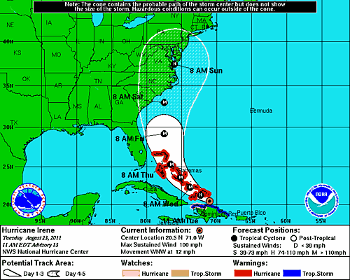
So I'll stick my neck out... I'm going to get very specific here... I'm going to give you intensity forecast and an exact location and general time of Irene landfall (where the eye wall comes ashore), as well as other areas that are going to feel those impacts and what those impacts will be... I'm using several numerical models, trends this season, and real time observations to generate this forecast.

Hint: if you want to skip all the blah, blah technical jargon... just flip straight to the bottom and I'll sum it all up for ya. THANKS!!

Yep, it'll all be in writing... for two reasons...

1. To go on record...
2. To show (if I happen to be wrong), that many times guidance is WAY off when it come to the day 4 and 5 forecast... NHC stats show a 200-250 mile margin of error when it comes to that many days out. So we can all laugh at the silly weatherman later.

In the meantime... here we go:

I think Irene is going to be a major hurricane at landfall... I'm talking a strengthening Cat 3 storm. It's going to miss the mountains of Hispanola and going to be moving through some very warm water. Upper level conditions (according to ONE MODEL) seem very favorable with an upper level anti-cyclone (high pressure) situated over Irene Tuesday and Wednesday as it emerges from all the rocks of the islands and into relatively open water. Here's the latest (as of this writing) GFS for Wednesday afternoon, paying closer attention to the 200mb chart, that's way up there... you can see wind barbs pointing in a clockwise flow above our storm.

That upper level high, over the surface low vents the storm, helping it grow.

So conditions seem right for this one to be strong... winds in the 120 mph range, but, again, getting stronger at landfall.

So where and when...

When is fairly easy, so we'll knock that out now... Saturday morning. Done and done.

No how bout where?

ridge shifts into western atlantic midweek... trough tries to get in here by Thursday... hmmmmm... sorry just thinking aloud here...

I really think, given the trends and how steering currents are looking, that this storm will recurve, so I think south Florida and the west coast should be in the clear, though they are certainly still in the cone. They have every reason to tell me I'm way off base etc...etc.

So, that leaves an area from Jacksonville to Myrtle Beach that I think we should focus on...

Historically, Jacksonville and the rest of the Ga-Fl bight get missed... I'm not going to buck that trend here. I think it recurves and does not make a direct landfall on Jacksonville. I do however think we will get hurricane conditions here... with some very strong winds and rain as Irene skirts our coastline late Friday night into Saturday morning.

This is not going to be a Wilmington, outter banks storm... at least I don't think so.

So that leaves an area between Savannah, Georgia and Myrtle Beach.

Maybe I'm drawing a wrong conclusion here... but this storm reminds me a lot of Hurricane Floyd, although Floyd tracked in September and a couple hundred miles to the north. Floyd stayed north of the Bahamas, made that massive recurve, and then plowed into NC.

Keeping that in mind... since Irene is a little further south now... I think landfall will occur a little further south. How bout we go down the coast a couple hundred miles.

How about Edisto,SC? That's what I'm sticking with for now at least. I'm not going to say Beaufort or Fripp Island, SC that's where I grew up and where my parents work and live (though what's a couple of miles between friends?)... but I really an concerned about a SC landfall this weekend.

So there we go... my official (unofficial) primary Irene forecast... I will probably change this 25 times before tomorrow... but what the heck... this was fun right?

IF YOU ARE SCROLLING DOWN STOP HERE:

Concise forecast for scrollers:

Irene makes landfall Saturday morning as a strengthening Cat 3 Hurricane (120mph winds) between Savannah, GA and Charleston, SC (I'm picking Edisto, SC as the spot Jim Cantore sets up shop), Jacksonville, the First Coast and SE Georgia will get strong tropical winds (perhaps hurricane strength gusts), some flooding and will deal with beach erosion and very large surf.


There you have it folks... DISCLOSURE: I'm sure this will come back to bite me in my ---, please be gentle and remember my boss and chief meteorologist Tim Deegan is the one with the true final say and real official First Coast News forecast.

Just putting my name in the race.

-My God, what have I done?

Mahalo,
Lew