

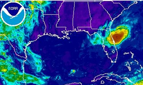
And on the first day we've got what looks a lot like a tropical system. A little dip in pressure, some thunderstorms with some minor circulation. Best I can tell, winds are gusting to around 25 to 30 mph according to the closest buoy.
The St. Augustine Buoy is going to give us the best readings until this thing actually moves over land.
Here's screen cap of the National Data Buoy Center info for the St. Augustine Buoy...

That's the rough position of this system... and no, those readings do not look all that impressive.
Right now, the best forecast track for this brings it through St. Johns, Flagler and Volusia County... with the strongest of the system moving in between St. Augustine Beach and Daytona Beach. Worst of it moving over and along I-4.
Winds won't make it to the 38 mph sustained mark to qualify this as a tropical depression before it moves across Florida today. It needs to spin over those warm Gulf Stream waters for a little longer, but it's 20 mph WSW track won't allow that. Right now sustained winds are at 15.5 knots, which is roughly 18 mph. Hmmmm... highly doubtful that this is Arlene. Highly doubtful indeed. Though that 30% circle in the pic at the top of the page is very interesting to see... that's an awfully high percentage from the NHC, at least in my opinion.
Still, this system could spark a few strong thunderstorms and some blinding downpours of rain from St. Augustine over to Putnam and down to Flagler in the First Coast News viewing area.
Meanwhile, the chance of rain for the Jacksonville area holds at around 30% today... mainly because of a line of storms developing off shore moving in.